How to do an actual search for land and property
I’ve updated this page with a little gem of information about online mapping and I’ve put an interesting example at the end of a search I carried out recently. I’ll drop pictures in later, but the text will give you the general idea.
There is another way to access Land Registry information which has their own map, presumably based on the map and data produced by LR. This is fantastic, doesn’t cost a penny to use, and provides a wealth of information that all the other systems have never done. The site is..
https://www.landregistry-uk.com/map-search
What this map shows is
- All the boundaries of any property listed or unlisted
- A simple way of knowing if the land is registered. If there’s a reference number then it is, if not, it isn’t. Couldn’t be simpler, or more clear.
What this means in real terms is that you can search, and instantly see what is registered, and what isn’t. Being able to see the actual boundary of a title is a huge bonus. I’ve previously gone field by field to see the extents of a property. This is immediate, very clear, and perfect for anyone trying to find land. The site won’t find anything for you, you still have to do that using the technique I describe below, but this speeds things up enormously. You can tell the properties that are unregistered as they have no clearly defined boundaries whereas every other property will have. You can recognise this when you see it.
It seems that this is a non-statutory organisation working with LR. Quite why they can’t just use this map on their main system makes no sense to me.
I’ve created a seperate page with full guidance how to use this mapping system, it’s at the bottom of the menu. As with everything else, practise is needed, and learning what to look for and recognise. After a while, this should become fairly easy.
The general searching process is described below
This is the process that I use, and find works best for me
The actual technique is;-
I simply pick a spot, often somewhere I just haven’t looked before. Or of course, somewhere you would choose to live if you could. To get the hang of this, practise somewhere very rural and see how you get on
Video 1 searching
I zoom in to around 250m (Bing shows the height on the bottom right corner).
And then it’s a case of attempting to be methodical and looking at anything that looks of interest. If I find something, I scroll closer, examine, then scroll back. How you cover an area is entirely up to you. It’s very hard to use a grid as you end up moving in a somewhat chaotic manner just to look at things more closely. Buildings and land doesn’t follow any kind of pattern, but forms itself around the landscape itself, so it really is hard to maintain a consistent searching pattern.
Unfortunately I don’t know of any app that will track my actual movements on a page to show me where I’ve been. It would make things a lot easier.
Sometimes I just end up clicking and moving from property to property, but it’s normally very easy to see active sites which of course I disregard. Be a little careful here as somewhere very active can still conceal buildings that have been virtually abandoned. I know one very active farm that has some derelict estate buildings virtually hidden in one corner.
Picture A8
One way is to scan side to side, move up at a certain point, repeat the process, and just keep doing this till you find something. Just be aware. This process is laborious and time consuming. You may not even find anything.
I normally do, wherever I look, but I’ve been doing it a while. It’s a bit like the people who could look at a blurry aerial photo during the war, and recognise where a tank regiment is hiding in the tree’s.
Oh, and there’s a strong chance you will end up going over the same area a few times without realising it. This may seem like a waste of time, but I’ve found a few places a second time around, so you never know. And you will never know which bits you may have missed as you looked in another direction.
In the same way I developed techniques to find country estates on maps, and even recognise the changes in landscape characteristics on the ground, I can now look at satellite images and find the things I’m looking for. It will probably take you a while to develop the same skill.
I normally keep tabs of different maps side by side on my browser, along with Google Earth, and land registry and planning maps for the area I’m searching. I will end up clicking between most of them If I find something of interest.
The scroll wheel on a decent mouse will be what you use constantly. You will be scrolling in and out all the time. All maps allow this
Doing it in practice
This series of photo’s shows a house, clearly in very good condition. Notice what appears to be the access to the property on the bottom left of the property, and how this appears almost unused some of the years. There appears to be very little going on here…
Also look at the way the grounds appear unkempt, and more so as time goes on. The surrounding trees also appear to be encroaching more each year
And yes, I have noted the red car that appears one year.
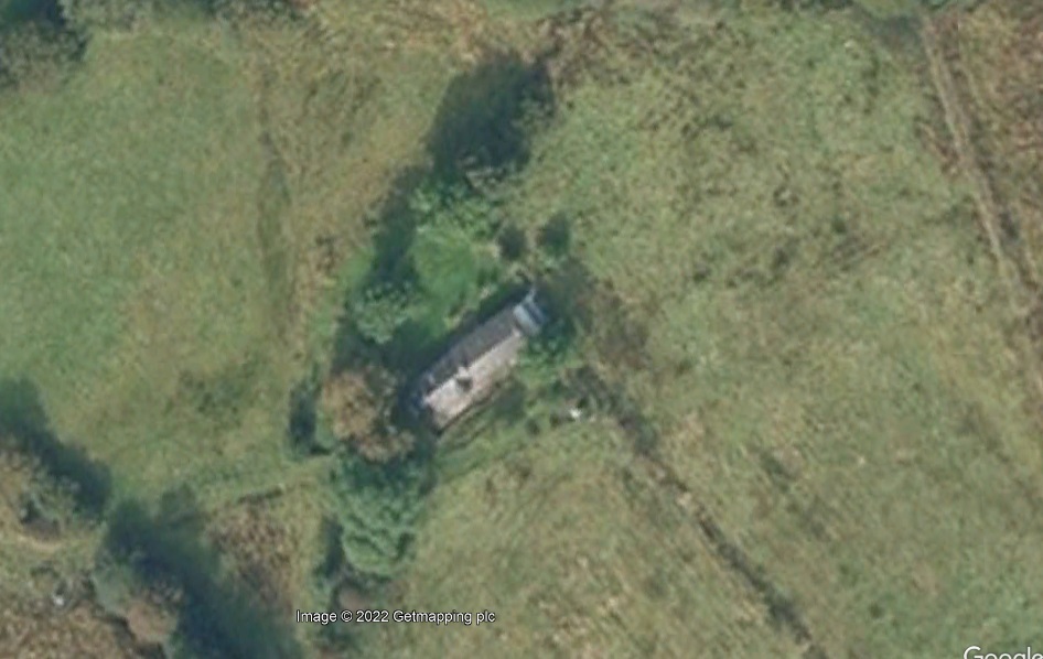
This is a location that I would definitely rate as well worth further investigation.
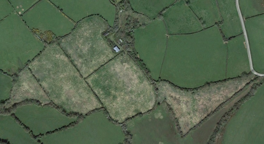
A2 this series show how easy it is to define the land and its management by its changing nature over the years. It’s quite easy to see the total extents by comparing it to the surrounding land.
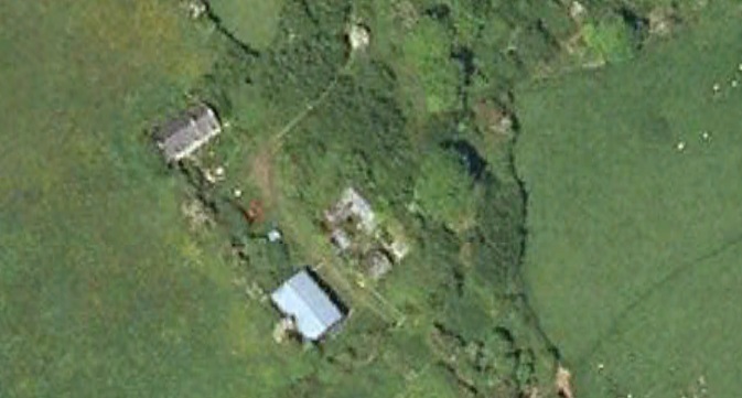
A3 this is a close up of the buildings at the heart of that block of land. You can clearly see how they are unused, and the roof of one has collapsed over the years. One some of the images it looks as if there is some traffic through the yard, but no evidence of people using the buildings themselves..
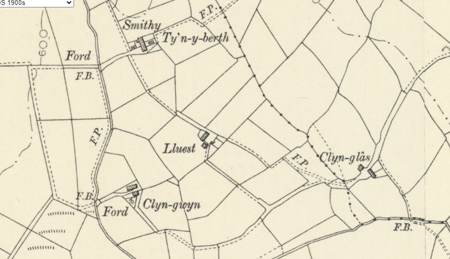
A4 This shows a comparison with google earth and Bing satellite images showing how the land looks now, and what appears on the 1905 map. There are still ruins of all those buildings concealed by the trees. You can also see the markers I use on Google maps. You can also see how one of the sites has completely disappeared.
You can also note how many of the field boundaries remain unchanged, but others have been ripped away, and the size of the fields enlarged.
A 5 another site with hidden buildings. One of the farms is almost completely ruinous but in a lovely location. The other has an almost complete house, albeit with part of the gable end gone. This also has the remains of a complete hydro power scheme, but I’m not sure what it ran..
As you can see, there is only a hint of buildings at one location. The only way to find places like this is to compare old maps to current satellite images..
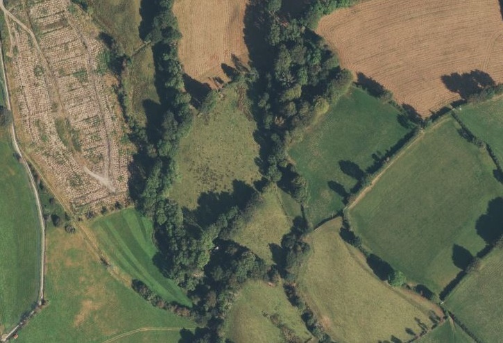
A 6. See how this site has gone from extremely busy in 2009, to seemingly abandoned in 2021. You can also see that the land, never well looked after has become more and more overgrown over time. Another tell-tale sign of somewhere with less use over time.
And the last detail is the track. Lots of use, and very clearly defined in 2009, almost completely out of use by 2021.
However, a word of warning. I have visited this site, discreetly. The track looks like nothing has been down in years, but there is someone still living there. That’s a hell of a change in a short period of time.
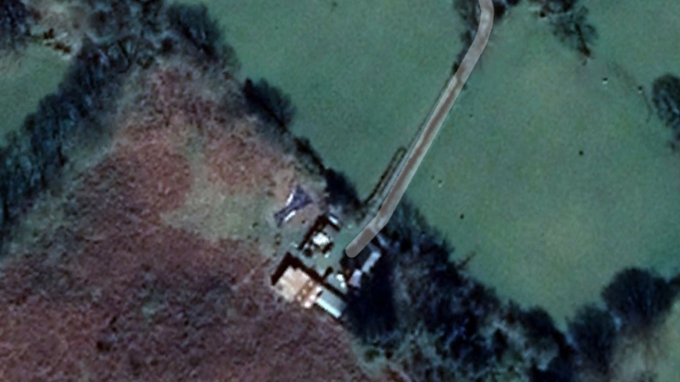
A 7 another example of concealed buildings clearly showing on 1905, and OS maps. As you can see on certain years where the foliage changes, the buildings are only shells, but otherwise appear to be very intact.
This location is well worth a visit.
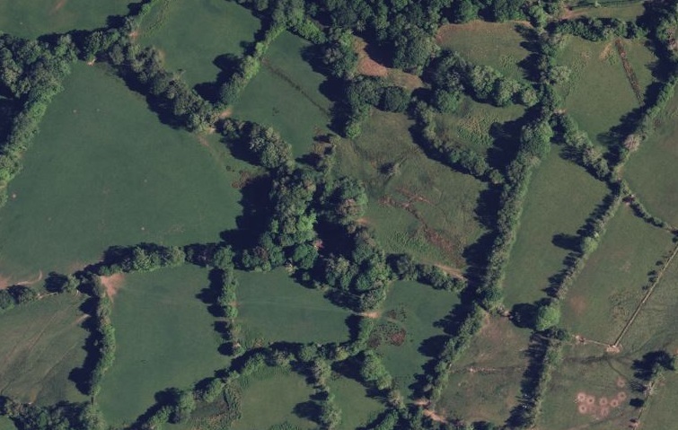
A 8 shows a seemingly modern farm with lots of large buildings, all well used and well maintained. What is harder to see is the small group of original buildings, remnants of a country estate, still complete, but being allowed to deteriorate rapidly. It would be an incredible waste if they never get rescued
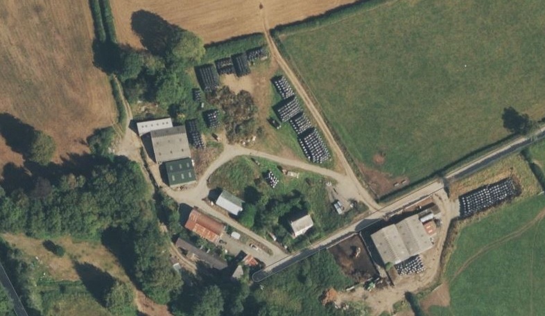
A 9 an unusual example of derelict buildings that are open and easy to see. Most places are completely covered by foliage in a short period of time.

Another thing to get used to is how to get a location on one map and find the same on another. The map on the Land Registry is spectacularly poor for this(recently updated and actually worse now!!). There is no way of aligning the actual maps, although some will allow you to just drop in the coordinates you’ve got from another map to take you to the same place(Bing, google, google earth).
The council mapping systems never seem to have any coordinate search systems either, so you will have to learn to recognise fixed features on one map, and match these with the same on another.I tend to use woodlands and roads.
Woodlands are great as they often end up with very distinctive shapes which can easily be recognised. One of the problems of looking on the non co-ordinate maps is that you will lose your location in order to look for a feature.
And again, this can be time consuming and laborious. Sometimes I can align the locations on different maps within seconds. At other times it has taken 10 minutes just to end up in the general area. Can be frustrating…very.
My process is to use Bing maps to find the property of interest. I find their images are clearer and easier to work with.
I will switch between satellite images, and OS mapping so I can see the access, other properties, and if there is a footpath near the property(i.e. Can I legitimately wander past for a closer look)
I copy the coordinates and drop these into google maps.
This will show a slightly different view, often taken at a different time.It also allows me to look at street view. It shows me the access, how well used this is, or appears to be(beware as streetview can be quite old), and more importantly, how visible the property is from the nearest road.
I then do the same with Google Earth. I can then click through the historical satellite images going back to around 2005, nearly 20 years. A lot can happen in that time. The Images for some periods are a lot clearer than others, and you can see changes over time.
I will often compare with the 1905 OS maps. This will show what existed at that time. It’s amazing how often so little will change over time.
I look at the land registry, usually using the mapping facility. Initially just to see if the property is registered, last date of sale, and a value or price. I don’t start getting actual documents until I have clarified if the property is actually in the condition it appears to be.
I look at the local planning map. Most areas have these, and they show any application made in the last 10-15 years in most cases.
Then, for the most interesting, or promising properties, I actually visit and get a much closer look.
Cut and pasting coordinates into any other map
I would recommend Bing for this as they provide a coordinate to six decimal places. Google does the same, but to fifteen decimal places. I have no idea why all this extra information is there, for most purposes it makes no difference whatsoever.
Google maps, right click then click on the coordinates at the top
Bing maps, right click then click on the coordinates at the bottom of the list
The Scottish National Library maps will go straight to a location, but they want a grid reference to do this. There is an online convertor here.
https://gridreferencefinder.com/batchConvert/batchConvert.php
It’s a bit of extra effort, but a lot easier than searching manually on an old map with little detail, and no colour to guide you.
So what is it you are actually looking for? What are the telltale signs?
What you are looking for is evidence of
The fact that a property is even there.
There are lots of properties that have become so obscured by the surrounding foliage that they have virtually disappeared. This may seem almost incredible, but nature starts to reclaim anything that isn’t regularly maintained, very quickly. Continuing this process over 20 or 30 years and it’s almost amazing how, even a complex system of buildings can become invisible and impossible to distinguish from the general environment.
Seeing whether a property has changed over time to the point that it appears to have been abandoned
This is where the process can actually become very difficult because the tell-tale signs of something being abandoned usually means that it is actually starting to blend back into its environment so most things become concealed with what looks like a normal background.
You will very rarely find a property where the surrounding land has been cleared just leaving a building sitting in the middle of an open piece of ground and therefore easy to see. A9
What is much more normal is that trees start to grow closer and closer to the property as time goes on, filling up every available space, and it doesn’t take long for them to start to cover the actual property themselves.
So normally what you look for are things that may seem out of place. for instance looking at what appears to be a piece of woodland but then you can see what is clearly a very linear or straight shape somewhere within it. This is one of the key things about man-made structures, they are normally Square and buildings are normally arranged in an orderly fashion. This is a giveaway.
Look out for field margins that are expanding. Farms may start to make use of land that has fallen out of use, but what they clearly don’t do is make any kind of investment in it. So fences become neglected, and what becomes more visible is that the boundary hedges will often become overgrown and start to encroach into the fields themselves. Land that has been completely abandoned will usually start to become overgrown from the margins inwards. In other words, it starts from the area of greatest biodiversity which will always be the boundary hedges which can often be a maelstrom of species.
Look for a property in an area where you would expect one to be. Most farms were formed a century ago, and usually had limited size. When you find large blocks of land with no farm buildings etc there may have been a holding there in the past
Blocks of woodland often conceal buildings that have been abandoned. Farms do not deliberately plant new woodland. The opposite is normally the case, woods and field boundaries get removed. So where there is clearly woodland where none existed previously, there may be a hidden property.
See where tracks are going to. If there is a track, there will be a purpose to it. They often lead to places that have become disused, although sometimes they do only lead to other fields or pieces of land.
Compare historical mapping to current satellite images
Look for blocks of land where the type of usage is unclear. Woodland is usually consistent in look, and nature.
Farmland in current use will have a distinct look. You can usually tell the extent of most farms because their land will all look the same colour, and its characteristics will remain similar. This is because how they manage and maintain the land will normally be very consistent. A farm that uses a slightly different technique will actually look different from the air. This becomes very clear with practice.
Where something is neither one, not the other it may well be fields that have fallen out of use, and become overgrown.The growth pattern will not be consistent, giving you a clue. Again compare old maps which will show old field boundaries. Any land currently being used will have some signs of active management. For instance, you will see evidence of tracks being formed by farm animals following routes across fields, and in and out of entrances and gates. The absence of these suggests that the land isn’t in use.
There will often be evidence of tractors driving across the land as they cut, seed, fertilize, or top the land to cut back overgrowth. Again evidence of this can become visible. This is where the Google earth ability to look at different years can be helpful as these signs are often time limited and can dissapear over time.
Land that is no longer being maintained usually becomes irregular in its features. Managed land is often remarkably consistent in how it looks which means that anything that doesn’t match it draws you attention.
Another thing is to look for land that is clearly being managed, but with areas of other land that clearly doesn’t have the same use. The actual shapes formed by the various holdings can be very irregular, and especially so if neighbouring land is added, or lost over time. You can normally see the land that is linked together, not only will the colour and form be the same, but you will often see how field opennings will link into each other, showing how they are connected. Anything that is clearly different should be of interest.
Field boundaries are another important feature. They’re everywhere, and have been for thousands of years. If you find a large, irregular piece of land, and then compare it to the 1905 map, you’ll often be amazed at all the hidden features that suddenly emerge. Field boundaries will be there, but sometimes you just can’t see them anymore.
Follow this sequence of photo’s to see how the land use has clearly been changing, and not over a particularly long period. This property was subject to a transfer in 2016, suggesting that the owner would have died in 2014-5. So the fields show the decline of one owner, and what appears to be the slow rebirth of the property under the next.
Imagine if the property has been completely abandoned, and see what 20 years of neglect does to the land. In this case I would suspect that the large block to the right will slowly be brought back into use, and this will be seen on the images in the future.
A property type I’m currently seeing a lot of are smallholdings where there has clearly been a lot of activity over the years, gardens and features created, polytunnels and greenhouses erected, land being well used. Of course what then happens is that the fit 60 year old becomes a frail 70-80 year old, couples become singles through life changes, and all their projects, and unfortunately efforts get reabsorbed into the landscape, however, leaving tell tell signs for people like me to find.
I am finding lots of these, but a word of caution. Just because they’ve become overgrown, doesn’t mean they’ve been abandonned. The owners are often there, but living in much reduced circumstances. These may present other opportunities though for land sharing etc. I’m sure few people will be happy seeing their effort and work being wasted, and few can afford to pay others to look after such a place.
So to summarise
1.Finding what has become hidden or overgrown over time
2.Looking for obvious differences in land use
3.Looking for changes over time showing lack of use
4.Looking for what you know may well have existed, and see if it still does.
Here is an excellent example of a search I carried out a few weeks ago. I’ll drop pictures in soon.
Here is another example of how to develop a back story to an unregistered property by gathering information from a number of sources.
I found this by accident while I was gathering background info for another project. Whilst looking at a property in a location I am very familiar with, I decided to follow a lane on Google Earth, and in the process found this interesting property.
It proved to be an interesting find and gathering the information was a brilliant example of what you can find when there appears to be nothing.
I thought it would be useful to others to follow that journey so I’ll track through the various stages and how I searched, and what I found. The thing is, I do this so automatically now, I probably don’t realise how much I’ve actually learnt about doing this, and the skill that has developed over time.
This is a large plot of land on the edge of a well established village. It’s not obviously there, and is down a back lane, so probably only a small handful of people even know it exists.
- Using Google Earth I could see the land appeared overgrown. I confirmed this using Streetview which showed the land overgrown and the same basic view.
- I used the landsearch website to see where the boundaries are for all the nearby properties. They all seem to be bungalows built around the early 80’s, and all are in good condition and well looked after.The piece of land was shown as having no fixed boundary and therefore not registered. There was a bungalow the land shared a boundary with which was also not registered. I looked to see if there was any connection between the two properties which would suggest they are linked and therefore under the same ownership, but there is a fixed hedge between the two indicating they are distinct as far as ownership.
- Using the local planning website’s map facility, I looked at planning on the site and found an application to build 4 bungalows was refused in 1987. This then provided a name for the applicant.
- I looked at the planning for the nearby plots as they were all built around the same time. The nearest two had no obvious connection, but there were 4 other bungalows where the applicant had applied for permission. The application for these was in 1979.
- I searched each individual plot for their planning history. The planning permission was outline only which means that so called Reserved matters must then be applied for which has the detailed plans for the individual properties. Each therefore has a number of different listings for various planning matters over the years. Planning was 45 years ago so there is always a strong likelihood of numerous applications over the years. And there was
- The reserved matters applications were under different names, although two of them were under the same name, probably a small local developer. The reserved matters were applied for in the 80’s, so the original owner had sold off the plots to be built on and developed.
- I searched the planning website using the name to see if there were other applications listed. There were 4 in total. 2 for the 8 bungalows applied for here, another two for a building at another location. That gave me another address to investigate.
- Using the postcode and name of the property, I searched for the other address using the findmyaddress website. There was no property with that name under that postcode, so I tried using the name. I had to search through around 40 addresses before I found the right one. There was also a different way of spelling the name, so I tried searching using both permutations. Its not unusual to find bits of addresses are wrong. You need to get creative here.
- I now had a location for the other property. Planning on this had been later suggesting the person had lived there after the other development. The planning for that location had been for business use which could provide another avenue to search.
- I looked at the second property on LandSearch and found the second property wasn’t registered as well, suggesting its owner moved there pre 2000. If the property was registered, I would use the InspireID to search the land registry for the date of the last sale, and Zoopla or rightmove for any sales history. This would tell me if the person is likely to be there, or a timescale for when they probably left. I could end up with a dead end here if I have no idea where they went to.
- I looked at the planning map for this location and found other planning applications under what appears to be a misspelling of the persons name (putting an r into the name). These applications were under the same surname, and much later(2015) indicating that the family still lived at the address up till that point. The fact there is no registration for the property tells you they still do live there as any recent sale would be registered.
- I searched for a will, or probate record for the person. Given this was a landowner savy enough to be developing building plots in 1979, 45 years ago, he would probably have been in his 30’s to 50’s at the time, putting him from 75 to late 80’s if he’s still alive. I didn’t find a record.
- I searched ancestry for birth records. I found a few, but what was listed as a first name initial only came up as a middle initial in every case. There are a number of potential hits.
So here is what I have found out so far
The property isn’t registered, but had planning from 1979, and the same person got planning on another 4 plots and sold these off for development in the 1980’s. There has been no further attempt to get planning at the site. The owner at that time has another property about a mile away which remains unregistered. There is a more recent planning application at that address in 2015 showing the person still lives there. I should add that the land is on the edge of an existing settlement and there is a strong possibility of getting planning permission at some point. It’s also close to the sea so in many ways is potentially a prime location and probably very valuable.
So it would appear that the owner has just held onto a potentially valuable piece of land as an asset.
There are however a few things which may suggest the land was sold on. It’s now been 37 years since the last application. Anyone developing, particularly someone who has done this successfully in the past would be more likely to attempt to get planning periodically. In this case, they haven’t. That could suggest the land was sold and the owner, who may also be holding a potential land bank is long gone. Consider that the original owner didn’t appear to develop the plots himself, so may have just wanted to cash in on his assets at the time, in which case selling on the plot without the planning may have been a good plan. Bear in mind that when these plots were developed, they would have sold for a couple of thousand pounds each, and as the land had been agricultural, it may have been bought for a few hundred quid. This is relevent in that the actual cash investment in the land may be very small, particularly compared to what the land could be worth now(probably £2-300K with planning on it..well worth the effort to get it) This could however explain why it may become lost as a minor asset, hardly worth bothering with, years down the line.
So where can I go from here to widen the search. This is potentially a very valuable plot which has been abandoned so well worth pursuing.
- I can get the original planning applications. These should give a full name and more details. It will be worth seeing if the later applications are under the same name. There could still be a widow and children at the address, and not the original person.
- I can examine the birth and other records more. It’s amazing how often different records will throw up something. You could have hundreds of potential birth records, but find only one marriage listed for that name locally. A pretty clear pointer. And finding the name for a wife and children can give other avenue’s of research.
- I could try google, facebook etc. Who knows. A silver surfer, or could have kids or grandkids who are active. Try variations on names, addresses etc.
- The guy was running a business. Try companies house to see of there is a record. This will give a full name and usually a birthdate..a godsend.
- I can start to get historical property records for the adjacent properties. The fact most are registered means this is available, but you will have to make a request for what documents are available. There will be deeds somewhere showing how the land has been divided. Where someone is selling plots from a larger piece of land, you could track this back. There is a smallholding at the end of this lane, so probably a strong chance the person owned that, and just started to make good use of his assets. The original deeds for that property may tell that story. This is where you may have to invest a bit of case as well as time as every record will cost you. But you probably only need a few to get a better picture.
- I would of course visit the site itself. Just because it appears overgrown doesn’t mean that it is. I could be doing a lot of effort for nothing.
- I would look at the local development plan. Anyone with land at the edge of a village would want the line drawn to include their land, and as these are updated every decade, they are open to submissions from anyone as to what to include, what to leave out. And all this is public record. Older stuff of course may not be on the internet. You may find representations under a different name, in which case another avenue to pursue.
- And if all else fails, you could start knocking on a few doors asking questions.
- And of course, the other option.you could just land on the property, put a caravan on it, take a few good books and wait for someone to come knocking. If there is an owner, they won’t be long, and it may force them into getting it registered, or doing something with it.
Of course you may just find that the old geezer up the road did all right for himself, inherited a few bob over the years, and never actually needed to attempt to liquidate an asset he decided to hold onto decades ago. Of course there is the other possibility that, now onto his third marriage, he kept his ownership of that little bit of land as a back up plan just in case, and no-one, especially his family knows that he even owns it. The records are well hidden…oh, and he’s now ill, and will only last another year or two…
And a final point. This seems like a lot of effort, but in reality took no more than 10-15 minutes on a computer. This isn’t a huge piece of land, probably around an acre, but with development potential and the value of that, has now gone to the top of my, must find out more list!!